Rent Prices in Barcelona: An Interactive Metro Map Guide for Expats
For expats and locals alike, navigating the rental market in Barcelona can be a daunting task, especially given the city's diverse and often fluctuating rent prices. To help alleviate this confusion, a new interactive map has been launched, providing a detailed breakdown of rent prices across different metro stations in Barcelona.
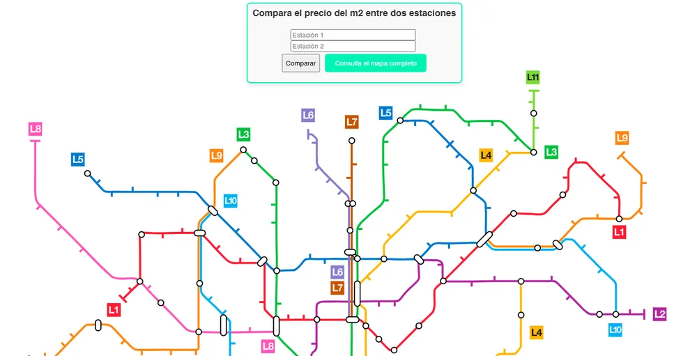
How the Map Works
The interactive map, available online, allows users to explore and compare the rent prices per square meter for various neighborhoods, each corresponding to a specific metro station. This tool is particularly useful for those looking to relocate or understand the cost of living in different areas of the city.
Rent Price Variations
The map reveals significant variations in rent prices across Barcelona. For instance, areas like Eixample and Ciutat Vella, which are central and highly sought after, tend to have the highest rent prices. In contrast, neighborhoods further from the city center, such as those in the districts of Nou Barris or Sant Andreu, offer more affordable options.
Practical Applications for Expats
For expats considering a move to Barcelona, this map is an invaluable resource. It helps in making informed decisions about where to live based on budget and preferred location. For example, if you are looking for a more affordable option while still being relatively close to the city center, areas like Poblenou or Sants might be worth exploring.
Additional Context: Market Trends and Challenges
The Barcelona rental market has been under scrutiny lately due to concerns over rising costs and potential abuses. The Platform for People Affected by Mortgages (PAH) has recently denounced the Spanish "bad bank" Sareb for including allegedly abusive clauses in rental contracts, which could lead to hidden rent increases and unfair debt claims.
Using the Map Effectively
To get the most out of the interactive map, users can zoom in on specific metro stations to see the average rent price per square meter in that area. This feature allows for a detailed comparison between different neighborhoods, helping potential renters to find the best fit for their needs and budget.
In summary, the new interactive map is a powerful tool for anyone looking to navigate the complex rental landscape of Barcelona. Whether you are an expat new to the city or a local looking for a change of scenery, this resource provides the clarity and detail needed to make well-informed decisions about where to live.
Related Stories

Northern Spain Named Best Global Destination for a Road Trip
Northern Spain wins title of best global road trip destination by Travelbook.de, celebrated for its stunning landscapes, rich culture, and scenic routes.

Discover the Best Cycling and Mountain Biking Routes in Cantabria
Explore the stunning cycling and mountain biking routes of Cantabria, Spain. From coastal paths to challenging mountain trails, discover routes for all skill levels amidst breathtaking landscapes.

Train Derailment Between Atocha and Chamartín Affects Thousands of Commuters
Train derailment in Madrid tunnel disrupts 13,700 commuters, with ongoing efforts to restore service between Atocha and Chamartín stations.

Normality Restored in Spanish Rail Network After Disruptions
Spanish rail services to resume normal operations on Oct 21 after disruptions, ADIF confirms, marking an end to weeks of travel chaos for commuters and tourists.

Illegal Tourist Rentals Surpass Legal Ones in Menorca, Raising Alarms
Illegal tourist rentals in Menorca now outnumber legal ones, posing threats to the island's sustainability and living costs, with calls for urgent regulatory action.